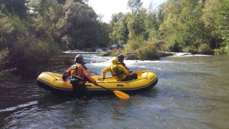
 Now it's possibile to discover the Mugello area in an unsual way: rafting, kayaking with canoes and SUP. On the Sieve river but also on Lake Bilancino.
Rafting Sieve river: https://www.t-rafting.com/project/rafting-sieve-bilancino/
Packrafting Sieve river: https://www.t-rafting.com/project/packrafting-sieve-mugello-e-valdisieve/
Packrafting lake: https://www.t-rafting.com/project/packrafting-lago-di-bilancino/
Kayak lake: https://www.t-rafting.com/project/kayak-lago-di-bilancino/
SUP lake: https://www.t-rafting.com/project/sup-lago-di-bilancino/
The “Sentieri Blu” (blue tracks) maps of Mugello and Valdisieve. The “Sentieri Blu” map of Mugello and Valdisieve is the map of the rafting itineraries on the Sieve River and other waterways in Mugello and Valdisieve. This map provides information on how to use the river for excursions by raft, kayak and SUP (Stand Up Paddle Board). The network of Sentieri Blu compliment the land trails: together they form one sole REG (global excursionist network) that unites different elements (land, water and air), and the diverse activities one can enjoy there (trekking, paragliding, cycling, horse riding, kayaking, rafting etc..).
Accessible water routes: gauging station and streamflow. Waterways are not always accessible for water sports: they may be either too low or too high, making them inaccessible. The river “conditions” (gauge height, expressed in centimeters, and/or streamflow, expressed in square meters per second (m3/s) are closely monitored with an instrument called a river gauge, which is used to measure the “water level”, or rather, the difference between the surface of the water and the bottom in a given reference point. This device, which is used to safeguard the territory when there is risk of flooding, is also used to provide information on the conditions and navigability of a river. In Tuscany, the “Centro Funzionale Regionale” provides online information every fifteen minutes. This updated data on the water levels of the principal waterways can be found at the web site: www.cfr.toscana.it
Minimum and maximum water levels for the Sieve River and other waterways. The minimum and maximum levels monitor the navigability of the waterways. This is important data needed to evaluate when and where to navigate, which is a personal choice based on the acknowledgement of the risks, but also based on the experience, the knowledge of the environment, the possible dangers found therein, and overall technical skill of the individual. Please note that high water levels modify the specific tracts of a river, altering the reference points. When this information was compiled by the authors of this map in May 2017, the principle reference points were as follows:
|
Waterway |
Section |
Area of reference |
water level min |
water level max |
| Sieve | Bilancino >>> Borgo San Lorenzo | San Piero a Sieve | 0,90 | 1,25 |
| Sieve | Ponte a Vicchio >>> Dicomano | Dicomano | 0,35 | 1,20 |
| Sieve | Dicomano >>> Rufina | Dicomano | 0,45 | 1,40 |
| Sieve | Rufina >>> Pontassieve | Fornacina 2 | 0,70 | 1,50 |
| Arno | Sant’Ellero >>> Pontassieve | Incisa valle/valley | 0,90 | 2,00 |
| Arno | Pontassieve >>> Girone | Nave di Rosano | -0,50 | 1,50 |
| Santerno | San Pellegrino >>> Moraduccio | Firenzuola | 0,70 | 1,20 |
| Lamone | Valbura >>> Marradi | Marradi | 0,45 | 0,75 |
Difficulties: Wildwasser WW levels
WW grades (wildwasser, eau vive, whitewater) are internationally recognized by the ICF (International Canoe Federation). They are expressed in 6 grades or classes. Please note that in a given section of a river the difficulties differ greatly with the streamflow. Sudden, quick variations (even in a span of hours) can be met with for various reasons, such as fallen trees or other obstacles. A river whose streamflow is too low, or too high cannot be classified. The following description is from the site www.ckfiumi.net in accordance with European guidelines. I WW basic. Static bottom with very few waves, regular and sparse on the surface. Light current, possible yet limited and avoidable whirlpools. The rapids are wide and free of obstacles. Linear, clear trajectory. Very modest descent. II WW not difficult. Waterway with easily avoidable obstacles, wide and clearly visible. The descent is linear and easy to follow, although with the necessity of ample maneuvers. An exciting descent that gives one satisfaction but not a fright. III WW standard – medium difficulty. Waterways with a succession of fairly difficult rapids separated by small lakes, waves and holes that can block the descent and submerge the kayak entirely.
These rapids have obstacles that call for swift and efficient maneuvers. The execution of precise maneuvers without reserve is mandatory, as is prior experience on easier courses, and a knowledge of real rapids. IV WW moderate, difficult.Waterways with giant irregular waves, and the presence of holes to be quickly avoided or passed over with force and decision at the right time and in the right direction, or small waterfalls, drops, and required passages. Difficult rapids to be navigated with the use of good, strong maneuvering techniques. Quick, unpredictable course on which it is easy to give up. The IV grade means that swimming becomes dangerous, and it is impossible for companions to intervene: to take on these rapids we must be masters of the kayak in all conditions. Preventive recognition is necessary before taking on IV grade waterways. Often the rapids are not much more difficult than III grade rapids, but they are much longer, increasing the overall difficulty greatly. V WW very difficult. Difficult passages with deep holes that tend to hold the kayak back. Areas of still water. Rapids may present huge rocks with narrow passages, waves and sudden, violent currents. Mastery, technique, timing, strength, fitness and an awareness of the dangers are a must for this class of rapid. Grade 5 rapids present considerable risks for everyone, even experts. VI WW extremely difficult. These rapids are considered to be so dangerous that they are effectively unnavigable on a reliably safe basis. Great mastery, courage and passion are needed to conquer these rapids, and even then they may not be safe. Any minimum error can be fatal.
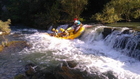 THE MONTONE RIVER BASIN: Although the Montone River flows between Tuscany and Romagna, it is included here, because its main tributary, Troncalosso, is in Tuscany. This waterway, for experienced canoers, presents an average difficulty of IV, with tracts that are higher (V). Maximum attention, therefore, is a must, and it is recommended for experts only. The landscape is beautiful, obviously, since the river lies at the margins of the Foreste Casentinesi National Park, and receives its water from the Fossa dell’Acquacheta, which lent its name to the famous waterfall cited by Dante.The Sieve River, ITS tributaries Comano, Moscia, Fistona, Faltona and the Lake of Bilancino.
THE SIEVE RIVER BASIN: The Sieve River presents variable difficulties that range from grade I to III, and it is navigable by raft, kayak and SUP. The river offers numerous boarding and landing areas, which offer a variety of different possibilities for different needs and levels of experience: from starters to experts, according to the water levels and streamflow. It can be navigated all year long, depending on the level of expertise; it is monitored at three points near San Piero a Sieve, Dicomano and Fornacina. The Bilancino dam interrupts the river, forming a lake whose waters are suited for swimming, canoeing and SUP. Some tributaries can be navigated only by kayak, among these we have Comano, much more interesting and difficult (up to grade III+). There are many interruptions along the Sieve River and its tributaries: maximum attention is needed, and guarantees a safe navigation!
THE SANTERNO RIVER BASIN: The Santerno River is the second biggest river in Mugello after the Sieve River. Its basin offers sections that are particularly beautiful and interesting for kayakers, with areas that are fairly difficult and can go as high as grade IV depending on the water level and streamflow. The “classic” tract, from San Pellegrino to Moraduccio, is monitored by the Firenzuola-Coniale river gauge, while the Diaterna and Rovigo tributaries, which run through the wild valleys of the Apennines, are not monitored, but can be navigated only after heavy rains.
THE LAMONE RIVER BASIN: The Lamone torrent and the Campigno tributary, dear to the poet Dino Campana, are treasures of the Tuscan-Romagna Apennines. The water runs over slabs of sandstone, which create natural slides and drops in the forest. Both waterways present medium-high levels of difficulty, on average around grade IV. It is reserved for experienced canoers. The Marradi river gauge monitors the area and provides fairly adequate information on the navigability, which, in general is best after spring or autumn rains.
ARNO RIVER: Although the Arno River is neither in the Mugello nor the Valdisieve territory, it is an important river for rafting, kayaking, and SUP. It is navigable along the entire length present on the map. There is a particularly difficult tract that goes from Sant’ Ellero to Pontassieve with rapids that reach grade III (due to the Levane Dam), and an interesting, easier tract – both historically and environmentally – which goes from Pontassieve to the gates of Florence at Girone. Great care must be taken when crossing the artificial barriers given the ancient derivations for mills and fulling mills, but it can be navigated, depending on the water levels and streamflow, from start to finish by starters and experts. This makes it perfect for tours. The river gauge is set in Nave da Rosano.
You can try the adventure contacting: T-rafting - c/o Aquaterra A.S.D., Via Nencioni, 14 - 50135 Florence - Phone: +39 335 6844664 - 339 8979963 - www.t-rafting.com


